
Ìzołe Vèrzeni britàneghe
| British Virgin Islands (en) | |||||
|---|---|---|---|---|---|
|
|||||
 someja satełitar in novenbre | |||||
| Ino | God Save the King | ||||
| Bomò | «Vigilate» «Be Vigilant» | ||||
| Pozision | |||||
| Continente | nordamèrica | ||||
| Stato | Regno Unio | ||||
| Stato dezignà | Teritorio Britànico da Mar | ||||
| Capitałe | Road Town (it) | ||||
| Popołasion | |||||
| Totałe | 39 369 (2023) | ||||
| Densità | 260,72 hab./km² | ||||
| Demònemo | anglo-verziniano o anglo-verziniana o anglo-verziniani, anglo-verziniane ,
| ||||
| Idioma | inglezo | ||||
| Zeografia | |||||
| Parte de | Isole Sopravento (it) | ||||
| Àrea | 151 km²[1] | ||||
| Rente a | |||||
| Organizasion pułìtega | |||||
| Òrgano lejislativo | Càmara de ła Asenblea | ||||
| Prèmier de łe Ìzołe Vergini | Andrew Fahie (it) | ||||
| Menbro de | |||||
| Economia | |||||
| Moneda | dòłaro statunitense | ||||
| Còdazi de identifegasion | |||||
| ISO 3166-1 | VG | ||||
| ISO 3166-2 | VG | ||||
| Fuzo oràrio | |||||
| Domìnio de primo liveło | .vg | ||||
| Prefiso tełefònego | +1284 | ||||
| Tełèfono d'emerzensa | |||||
| Preza ełètrega | |||||
| Istòrego | |||||
| Sito web | bvi.gov.vg | ||||
|
| |||||


Le Ìzołe Vèrzeni Britàneghe łe ze un teritòrio de oltremare del Regno Unio inte łe Antiłe. Pì precizamente łe fa parte de l'arsipèłago de łe Ìzołe Vèrzeni[4].
Zeògrafia fìzega
[canbia | canbia el còdaxe]Le Ìzołe Vèrzeni britàneghe łe se cata intra el Mar de łe Antiłe a sud e el Osèano Atlàntego nordosidental a nord.
Le ze par ła pì granda parte de orìzane volcànega e dal profiło cołinar.
Le ze formae da pì de na sesantina de ìzołe; la pì estendesta ła ze Tortoła[5] (55,7 km²), łe sègue Vèrgen Gorda[6], Anegada[7] e Ioust Van Daik[8].
Intrà łe ìzołe menori łe ghe ze: Beef, Cooper, Ginger, Great, Guana, Mosquito, Necker, Norman, Peter, Salt, Scrub Island
Zeògrafia umana
[canbia | canbia el còdaxe]Le Ìzołe Vèrzeni Britàneghe łe ze un arsipèłago de pì de 60 ìzołe, 43 dezabitae e 15 de łe cuałe łe ze łe pì abitae intrà łe cuałe Tortoła, Anegada e Virgin Gorda.
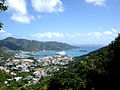
El caołogo ła ze ła sitadina de Rod Taun[9], situada inte l'ìzoła de Tortoła.
El cao del Stato el ze el sovran del Regno Unio che el ezèrsita łe so funsion mediante de un goernatore; a st'ùltemo łe ghe speta, soto del mandà del sovran, racuanti incarghi intrà i cuałi cueło là de ła nòmena del premier.
Gałeria de someje
[canbia | canbia el còdaxe]-
 panorama de Ioust Van Daik
 -
 panorama de Vèrgen Gorda
 -
 panorama de Rod Taun
 -
 Cyclura pinguis, retiłe endemego


Notasion
[canbia | canbia el còdaxe]- ↑ URL de refarensa: https://www.cia.gov/the-world-factbook/countries/british-virgin-islands/summaries/#geography.
- ↑ URL de refarensa: http://www.unesco.org/eri/cp/ListeMS_Indicators.asp.
- ↑ 3,0 3,1 voze de refarensaiec.ch.
- ↑ repartio intrà Regno Unio e Stati Unii de l'Amèrica
- ↑ in ingleze Tortola, /tɔːrˈtoʊlə/
- ↑ in ingleze Virgin Gorda, /ˈvɜːrdʒən ˈɡɔːrdə/)
- ↑ in ingleze
- ↑ in ingleze Jost Van Dyke, /ˈjoʊst væn ˈdaɪk/
- ↑ in ingleze Road Town
Riferimenti
[canbia | canbia el còdaxe]- Vassilis K. Fouskas. 2003. Zones of Conflict: U.S. Foreign Policy in the Balkans and the Greater Middle East. Pluto Press. ISBN 0-7453-2030-9. Pp. 93, 111
Altri projèti
[canbia | canbia el còdaxe] Wikimedia Commons el detien imàjini o altri file so Ìzołe Vèrzeni britàneghe
 el detien schemi gràfeghi so
Ligadure esterne
[canbia | canbia el còdaxe]- Sito ufisałebvi.gov.vg.
- (EN) British Virgin IslandsEnçiclopedia Britannica, Encyclopædia Britannica, Inc.
- Sovereign Base Areas Administration web-pages
- BBC News- "UK offers to cede Cyprus land"
- BBC News- "Cyprus protesters clash at UK base"
- Paxena del CIA World Factbook su Akrotiri
- Paxena del CIA World Factbook su Dhekelia
- - The Princess Mary's Hospital RAF Akrotiri
| Controło de autorità | VIAF (EN) 124830565 · LCCN (EN) n82031609 · GND (DE) 4063590-9 · WorldCat Identities (EN) n82-031609 |
|---|