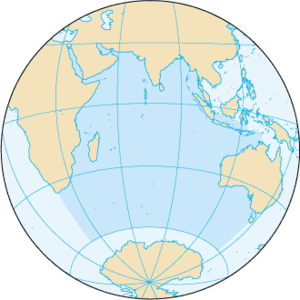
Osèano Indian
 | ||||
| Sorte | Osèano, mar e rejon zeogràfega | |||
|---|---|---|---|---|
| Epònemo | India | |||
| Parte de | osèano mondiałe | |||
| Posto | ||||
| Rejon aministrativa | nisun vałore | |||
| Rente a | Chisimaio (it) Àfrica Austrałe Osèano Atlàntego Osèano Pasìfego Osèano Antartego | |||
| Formà da | ||||
| Conca idrogràfega | conca del osèano Indian | |||
| Dati e sifre | ||||
| Altitùdene | 0 m | |||
| Prodondità | màsimo: 7 450 m mèdio: 3 711 m | |||
| Mezura | 10 000 ( | |||
| Ponto pì baso | Abisso Diamantina (it) | |||
| Àrea | 76 174 000 km² | |||
| Mezure e indegadori | ||||
| Vołumi | 282 650 000 km³ | |||
|
| ||||
L'Osèano Indian el xe el terso osèano pì grande del mondo. El coverse sirca el 20% de ła superfisie de ła Tera.
El confina a ovest co el continente african, a nord e a nordest co el continente axiatico (Penìxoła Arabega, Subcontinente Indian, Penìxoła Indosinexe e l'Arsipełago de ła Sonda), a est co el continente austrałian, a sud co el continente antartico [1].
El meridian 20°E ło separa a ovest da l'Osèano Atlàntego; cheło 147°E ło separa a est da l'Osèano Pasìfego.
Zeografia fixega
[canbia | canbia el còdaxe]El coverse una superfisie de sirca 73 556 000 km², e el ga un vołume de sirca 292 131 000 km³.
Łe so ìxołe prinsipałi łe xe Madagascar e Sri Lanka; łe ìxołe de Sumatra, Giava e Tasmania łe se cata al confin con l'Osèano Pasifego.
Zeografia umana
[canbia | canbia el còdaxe]El Osèano Indian el xe un inportante via de comunicaxion tra Axia e Africa.
Note
[canbia | canbia el còdaxe]- ↑ Secondo serti giografi el riva soło che al parałeło 60°S, oltre del cual se pasa a l'Osèano giasal Antartego dito anca Osèano Austral
 Wikimedia Commons el detien imàjini o altri file so Osèano Indian
 el detien schemi gràfeghi so
| Controło de autorità | VIAF (EN) 316429868 · LCCN (EN) sh85064984 · GND (DE) 4026737-4 · BNF (FR) cb15297514t (data) · BNE (ES) XX455949 (data) · NDL (EN, JA) 00564107 · WorldCat Identities (EN) 316429868 |
|---|

