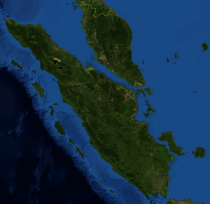
Sumatra
Inpostasion de letura
| (id) Sumatra | |||||
 | |||||
| Sorte | Ìzoła | ||||
|---|---|---|---|---|---|
| Parte de | Grandi Isole della Sonda (it) | ||||
| Rejon zeogràfega | Grandi Isole della Sonda (it) | ||||
| Posto | |||||
| Continente | Àzia | ||||
| Rejon aministrativa | Indonèzia | ||||
| |||||
| Bagnà da | Osèano Indian | ||||
| Dati e sifre | |||||
| Altitùdene | 12 m | ||||
| Mezura | 370 ( | ||||
| Perìmetro | 4 869 km | ||||
| Ponto pì alto | Kerinci | ||||
| Àrea | 473 481 km² | ||||
|
| |||||
Sumatra ła xe ła sesta pì estexa ìzoła del pianeta, co na superficie de sirca 470 000 km² e ła xe ła tersa ìzoła pì granda de ł'arzipełago Indonexian dopo Nova Guinea e Borneo.

Ła zona ła xe sojeta a riscio sismego. Intra łi teremoti pì significativi se ricorda cheło del 26 de diçenbre 2004, in seguito al cual ła ga subìo anca el conseguente tsunami, e cheło del 28 de marso 2005 de intensità intrà i 8,2 e i 8,7 gradi de ła scala Richter che el ga intaresà ł'intiera area nord-osidentałe de ł'Indonexia.
| Controło de autorità | VIAF (EN) 315129124 · LCCN (EN) sh85130407 · GND (DE) 4058586-4 · BNF (FR) cb12020255p (data) · BNE (ES) XX457644 (data) · NDL (EN, JA) 00628653 · WorldCat Identities (EN) 315129124 |
|---|


