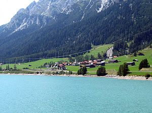
Sufers
Inpostasion de letura
| Sufers (de-ch) | |||||
|---|---|---|---|---|---|
|
|||||
 | |||||
| Pozision | |||||
| Stato | Svìsara | ||||
| Canton | Canton Grixoni | ||||
| Popołasion | |||||
| Totałe | 144 (2018) | ||||
| Densità | 4,16 hab./km² | ||||
| Zeografia | |||||
| Àrea | 34,62 km²[1] | ||||
| Bagnà da | Fiume Reno Posteriore | ||||
| Altitùdene | 1 430 m-1 890 m | ||||
| Rente a | |||||
| Còdazi de identifegasion | |||||
| Còdaze postałe | 7434 | ||||
| Còdaze de matricołasion | GR | ||||
| Fuzo oràrio | |||||
| Prefiso tełefònego | 081 | ||||
| Còdaze BFS | 3695 | ||||
| Sito web | sufers.ch | ||||
|
| |||||
Sufers el xe un comun de ła rejon Viamala che ła fa parte del canton Grixoni in Svisara
Evołusion demografega
[canbia | canbia el còdaxe]Altri projeti
[canbia | canbia el còdaxe] Wikimedia Commons el detien imàjini o altri file so Sufers
 el detien schemi gràfeghi so
Łinganbi foresti
[canbia | canbia el còdaxe]- ↑ voze de refarensabfs.admin.ch.
| Controło de autorità | VIAF (EN) 246277913 · LCCN (EN) nr93045555 · GND (DE) 4247478-4 · BNF (FR) cb12310389k (data) · WorldCat Identities (EN) nr93-045555 |
|---|


