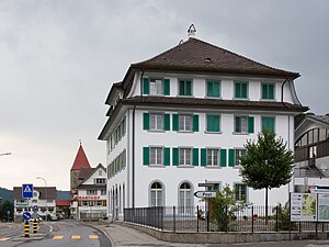
Rothenthurm
Inpostasion de letura
| Rothenthurm (de-ch) | |||||
|---|---|---|---|---|---|
|
|||||
 | |||||
| Pozision | |||||
| Stato | Svìsara | ||||
| Canton | Canton Svitto | ||||
| l canton Svito | Svito | ||||
| Popołasion | |||||
| Totałe | 2 412 (2018) | ||||
| Densità | 105,79 hab./km² | ||||
| Idioma | todesco | ||||
| Zeografia | |||||
| Àrea | 22,8 km² | ||||
| Altitùdene | 925 m | ||||
| Rente a | |||||
| Còdazi de identifegasion | |||||
| Còdaze postałe | 6418 | ||||
| Còdaze de matricołasion | SZ | ||||
| Fuzo oràrio | |||||
| Prefiso tełefònego | 041 | ||||
| Còdaze BFS | 1370 | ||||
| Sito web | rothenthurm.ch | ||||
|
| |||||
Rothenthurm el xe on comun del distreto de Svito che el fa parte del canton Svito in Svisara
Evołusion demografega
[canbia | canbia el còdaxe]Altri projeti
[canbia | canbia el còdaxe] Wikimedia Commons el detien imàjini o altri file so Rothenthurm
 el detien schemi gràfeghi so
Łingambi foresti
[canbia | canbia el còdaxe]
| Controło de autorità | VIAF (EN) 246958758 · GND (DE) 4565260-0 · WorldCat Identities (EN) 246958758 |
|---|


