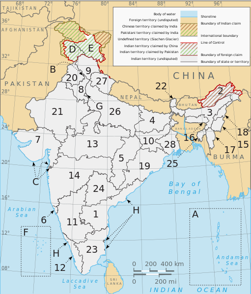
File:Political map of India EN.svg

Dimensioni di questa anteprima PNG per questo file SVG: 511 × 599 pixel. Altre risołusion: 205 × 240 pixel | 410 × 480 pixel | 655 × 768 pixel | 874 × 1 024 pixel | 1 748 × 2 048 pixel | 1 594 × 1 868 pixel.
File orixenałe (file en formato SVG, dimension nominałi 1 594 × 1 868 pixel, dimension del file: 325 KB)
Istoria del file
Schicia so on grupo data/or pa vedare el file come che el se presentava in tel momento indegà.
| Data/Ora | Miniadura | Dimension | Utente | Comento | |
|---|---|---|---|---|---|
| In ultima | 15:49, 28 set 2022 |  | 1 594 × 1 868 (325 KB) | ऐक्टिवेटेड् | File uploaded using svgtranslate tool (https://svgtranslate.toolforge.org/). Added translation for sa. |
| 21:30, 27 ago 2022 |  | 1 594 × 1 868 (312 KB) | Johano | File uploaded using svgtranslate tool (https://svgtranslate.toolforge.org/). Added translation for eo. | |
| 00:34, 24 ago 2022 |  | 1 594 × 1 868 (310 KB) | Johano | File uploaded using svgtranslate tool (https://svgtranslate.toolforge.org/). Added translation for eo. | |
| 07:30, 3 luj 2020 |  | 1 594 × 1 868 (300 KB) | Jfblanc | removed I-mark and replaced by H (thanks Wassermaus!) | |
| 17:56, 7 avr 2020 |  | 1 594 × 1 868 (299 KB) | Jfblanc | Merger of UTs of Dadra & Nagar Haveli with Daman and Diu (26 January 2020). | |
| 09:47, 19 nov 2019 |  | 1 594 × 1 868 (293 KB) | Getsnoopy | Complete code overhaul for easier manipulation. Corrected JK and Ladakh border in PaK. Adjusted some label positions and some other styles. | |
| 22:12, 8 nov 2019 |  | 1 594 × 1 868 (318 KB) | Getsnoopy | Reverted to version as of 14:11, 2 November 2019 (UTC) | |
| 22:10, 8 nov 2019 |  | 1 594 × 1 868 (291 KB) | Getsnoopy | Complete code overhaul for easier manipulation. Corrected JK and Ladakh border in PaK. Adjusted some label positions and some other styles. | |
| 16:11, 2 nov 2019 |  | 1 594 × 1 868 (318 KB) | RaviC | adjustments made following publication of official boundaries of new UTs | |
| 04:06, 1 nov 2019 |  | 1 594 × 1 868 (318 KB) | Getsnoopy | Fixed Puducherry's letter mappings, and made some minor arrow adjustments as a result. |
Doparasion del file
Ła pajina che vien ła dopara sto file:
Doparasion globałe del file
St'altre wiki cua le dopara sto file:
- Uxo de ace.wikipedia.org inte le pàjine
- Uxo de as.wikipedia.org inte le pàjine
- Uxo de bat-smg.wikipedia.org inte le pàjine
- Uxo de be-tarask.wikipedia.org inte le pàjine
- Uxo de bh.wikipedia.org inte le pàjine
- Uxo de bn.wikipedia.org inte le pàjine
- Uxo de bs.wikipedia.org inte le pàjine
- Uxo de cs.wikipedia.org inte le pàjine
- Uxo de da.wikipedia.org inte le pàjine
- Uxo de en.wikipedia.org inte le pàjine
- India
- ISO 3166-2:IN
- Central Reserve Police Force
- List of Indian state and union territory name etymologies
- Outline of India
- Talk:States of India
- Template:Indian states and territories image map
- User:RajatTikmany
- User:Srujan1001/sandbox
- User:RexxS/India (no clear)
- User:RexxS/India (20em cols)
- User:RexxS/India (15em cols)
- User:Berek/India
- Talk:India/Archive 46
- Uxo de eo.wikipedia.org inte le pàjine
- Uxo de es.wikipedia.org inte le pàjine
- Uxo de fi.wikipedia.org inte le pàjine
- Uxo de fr.wikipedia.org inte le pàjine
- Uxo de gl.wikipedia.org inte le pàjine
- Uxo de he.wikipedia.org inte le pàjine
Varda ła doparasion globałe de sto file.


