
File:L'île de la Réunion vue par le satellite Sentinel-2 (cropped).jpg

File orixenałe (5 000 × 4 232 pixel, dimension del file: 18,68 MB, tipo MIME: image/jpeg)
Somario
| Descrision |
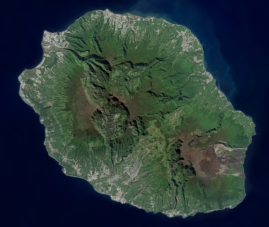
Français : L'île de la Réunion vue par le satellite Sentinel-2
English: Réunion island (Indian Ocean) photographed by Sentinel-2 satellite. |
| Data | |
| Provenjiensa | https://phototheque.cnes.fr/cnes/media/68926 |
| Autore | European Space Agency / CNES |
| Altre version |

.jpg)
| Posission de la màchina fotogràfega | | La posission de sta qua e de altre imagini su: OpenStreetMap |
|---|
.jpg¶ms=-21.134472_N_0055.247103_E_globe:Earth_type:camera__&language=vec)
Licensa de doparasion:

|
This image contains data from a satellite in the Copernicus Programme, such as Sentinel-1, Sentinel-2 or Sentinel-3. Attribution is required when using this image.
Atribusion: Contains modified Copernicus Sentinel data 2021
The use of Copernicus Sentinel Data is regulated under EU law (Commission Delegated Regulation (EU) No 1159/2013 and Regulation (EU) No 377/2014). Relevant excerpts:
Free access shall be given to GMES dedicated data [...] made available through GMES dissemination platforms [...].
Access to GMES dedicated data [...] shall be given for the purpose of the following use in so far as it is lawful:
GMES dedicated data [...] may be used worldwide without limitations in time.
GMES dedicated data and GMES service information are provided to users without any express or implied warranty, including as regards quality and suitability for any purpose. |

|
Questa immagine è stata valutata secondo i criteri per le immagini di valore ed è considerata l'immagine di maggior valore su Commons per l'argomento: Réunion island, France - satellite view.. Puoi vedere la sua valutazione qui. |
.jpg)
Istoria del file
Schicia so on grupo data/or pa vedare el file come che el se presentava in tel momento indegà.
| Data/Ora | Miniadura | Dimension | Utente | Comento | |
|---|---|---|---|---|---|
| In ultima | 16:12, 6 set 2022 | | 5 000 × 4 232 (18,68 MB) | Skimel | File:L'île de la Réunion vue par le satellite Sentinel-2.jpg cropped 15 % vertically using CropTool with precise mode. |
Doparasion del file
Ła pajina che vien ła dopara sto file:
Doparasion globałe del file
St'altre wiki cua le dopara sto file:
- Uxo de ar.wikipedia.org inte le pàjine
- Uxo de arz.wikipedia.org inte le pàjine
- Uxo de ast.wikipedia.org inte le pàjine
- Uxo de az.wikipedia.org inte le pàjine
- Uxo de ca.wikipedia.org inte le pàjine
- Uxo de ce.wikipedia.org inte le pàjine
- Uxo de cy.wikipedia.org inte le pàjine
- Uxo de diq.wikipedia.org inte le pàjine
- Uxo de es.wikipedia.org inte le pàjine
- Uxo de es.wikivoyage.org inte le pàjine
- Uxo de fr.wikinews.org inte le pàjine
- Uxo de fr.wikivoyage.org inte le pàjine
- Uxo de ga.wikipedia.org inte le pàjine
- Uxo de gl.wikipedia.org inte le pàjine
- Uxo de ht.wikipedia.org inte le pàjine
- Uxo de hy.wikipedia.org inte le pàjine
- Uxo de ia.wikipedia.org inte le pàjine
- Uxo de ig.wikipedia.org inte le pàjine
- Uxo de ku.wikipedia.org inte le pàjine
- Uxo de no.wikipedia.org inte le pàjine
- Uxo de oc.wikipedia.org inte le pàjine
- Uxo de pl.wikipedia.org inte le pàjine
- Uxo de ps.wikipedia.org inte le pàjine
- Uxo de tl.wikipedia.org inte le pàjine
- Uxo de vi.wikipedia.org inte le pàjine
- Uxo de www.wikidata.org inte le pàjine
.jpg)