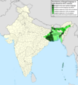
File:Geographic distribution of Bengali language.png

Contenuti de pajine no soportà in altre łéngue.
Da Wikipedia, l'ençiclopedia libara.

File orixenałe(2 806 × 2 080 pixel, dimension del file: 1,36 MB, tipo MIME: image/png)

Sto file el vien da Wikimedia Commons e se połe dopararlo in altri projeti. Sto cuà vien mostrà ła descrision prexente in te ła pajina de descrision del file.

Somario

Descrision
Ελληνικά: Γεωγραφική κατανομή της Βεγγαλικής Γλώσσας ανά επαρχία της Ινδίας και στο Μπανγκλαντές, τα χρώματα στις επαρχίες ποικίλουν ανάλογα με το ποσοστό ομιλητών (δεδομένα απογραφής 2011). Παράγωγο του αρχείου India district map (de-facto).svg.
English: Geographic distribution of Bengali language in India and Bangladesh. The map covers each district of India and the five shades of green show the percentage of Bengali language speakers in each district. Source: Indian census 2011. Feel free to enrich the map with data for more Indian districts, or fix any mistakes. Derivative of the file India district map (de-facto).svg.
Data
Provenjiensa Opara propia
Autore NikosLikomitros

Licensa de doparasion:

Mi, che detegno el dirito d'autor su sta opera, la pùblico qua soto la seguente licensa:
w:it:Creative Commons
atribussion spartisi in te ła stesa manjiera
Te si libaro:
  • de spartire in jiro – de copiar, distribuir e trasmétar sta opera
  • de modifegar – de adatar sta opera
Soto le seguenti condision:
  • atribussion – Te ghe da atribuir ƚa paternità de ƚ'opera ne i modi indicà de l'autor o da chi te gà dà l'opera en lisensa, e en modo tale da no sugerir che lori i sia d'acordo con ti o col modo che te dòpari l'opera.
  • spartisi in te ła stesa manjiera – Se te mis-ci, trasformi o dexviłupi sto laoro, te ghè da spartire łe to contribusion segondo ła stesa liçensa o na conpatibiłe a l'orixenałe.

Didascalie

Aggiungi una brevissima spiegazione di ciò che questo file rappresenta
Geographic distribution of Bengali language in India and Bangladesh. The map covers each district of India and the five shades of green show the percentage of Bengali language speakers in each district. Source: Indian census 2011.

Elementi ritratti in questo file

raprezenta a

Istoria del file

Schicia so on grupo data/or pa vedare el file come che el se presentava in tel momento indegà.

Data/OraMiniaduraDimensionUtenteComento
In ultima17:05, 2 luj 2022Miniadura de la version de le 17:05, 2 luj 20222 806 × 2 080 (1,36 MB)NikosLikomitrosA few districts of Arunachal Pradesh have a notable Bengali presence above of 1%, probably part of the Indian efforts to increase its presence in the region.
18:55, 1 luj 2022Miniadura de la version de le 18:55, 1 luj 20222 806 × 2 080 (1,36 MB)NikosLikomitrosTwo extra fixes.
18:53, 1 luj 2022Miniadura de la version de le 18:53, 1 luj 20222 806 × 2 080 (1,36 MB)NikosLikomitrosMinor fixes.
18:44, 1 luj 2022Miniadura de la version de le 18:44, 1 luj 20222 806 × 2 080 (1,36 MB)NikosLikomitrosNow, this map covers all districts of India. Includes also extra information and a new colour key. The basemap is from Distribution_of_Jats_in_South_Asia.png.
23:09, 26 xug 2022Miniadura de la version de le 23:09, 26 xug 20221 902 × 2 048 (1 002 KB)NikosLikomitrosUploaded own work with UploadWizard

Nisuna pajina ła dopara sto file

Doparasion globałe del file

St'altre wiki cua le dopara sto file:

Metadati

Traesto fora da Wikipèdia - L'ençiclopedia łìbara e cołaboradiva in łéngua Vèneta "https://vec.wikipedia.org/wiki/File:Geographic_distribution_of_Bengali_language.png"