
File:Caucasus-ethnic-1995.jpg

Dimension de sta anteprima: 512 × 599 pixel. Altre risołusion: 205 × 240 pixel | 410 × 480 pixel | 656 × 768 pixel | 875 × 1 024 pixel | 1 749 × 2 048 pixel | 2 606 × 3 051 pixel.
File orixenałe (2 606 × 3 051 pixel, dimension del file: 2,46 MB, tipo MIME: image/jpeg)

|
Ghe xe na version vetoriale de sta imagine ("SVG").
Te pol dopararla al posto de sta imagine raster co che xe necessaria na risolussion superiore. File:Caucasus-ethnic-1995.jpg → File:Caucasus-ethnic en.svg
Par savérghene piassè su la grafica vetoriale lèzi: Commons:conversion a SVG. Ghe xe anca informassion de suporto a le imagini SVG in MediaWiki. |
 |

|
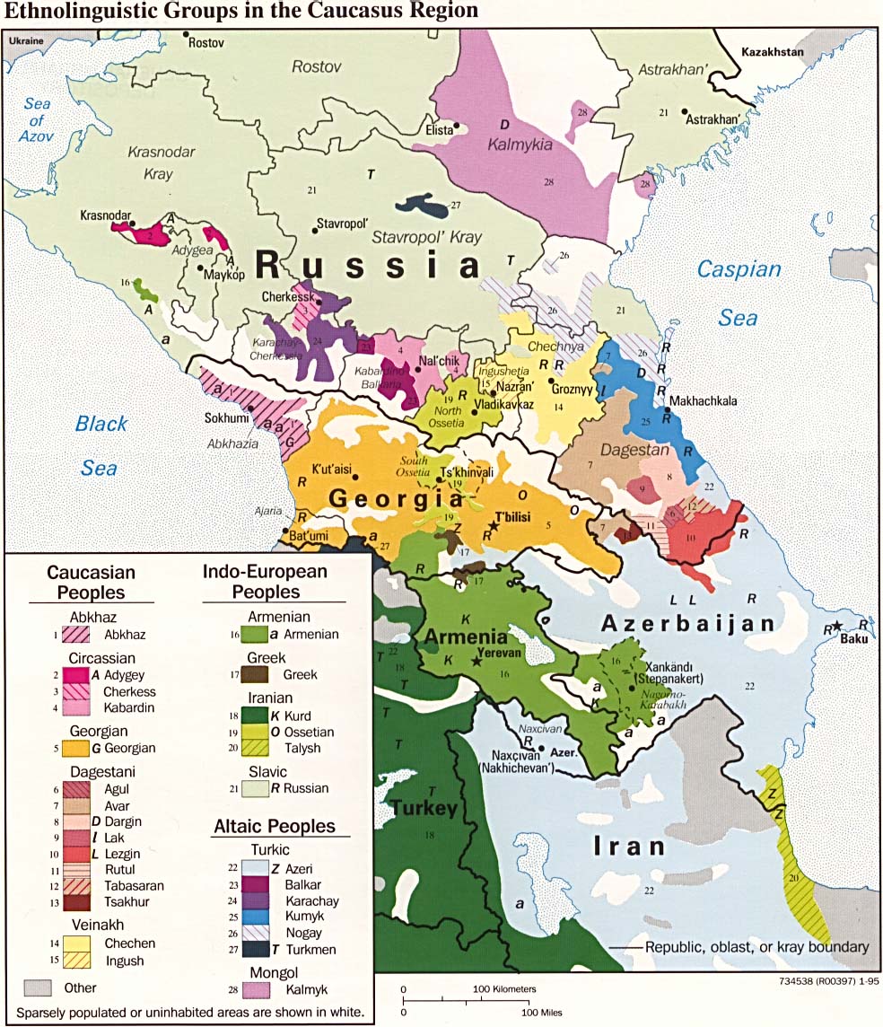
Ghe xe na version pi bèla de sto file, che se cata qua: File:Caucasus-ethnic-2004.jpg. Se racomanda quindi de doparar quel'imagine lì, invesse de sta qua.
|

|
Somario
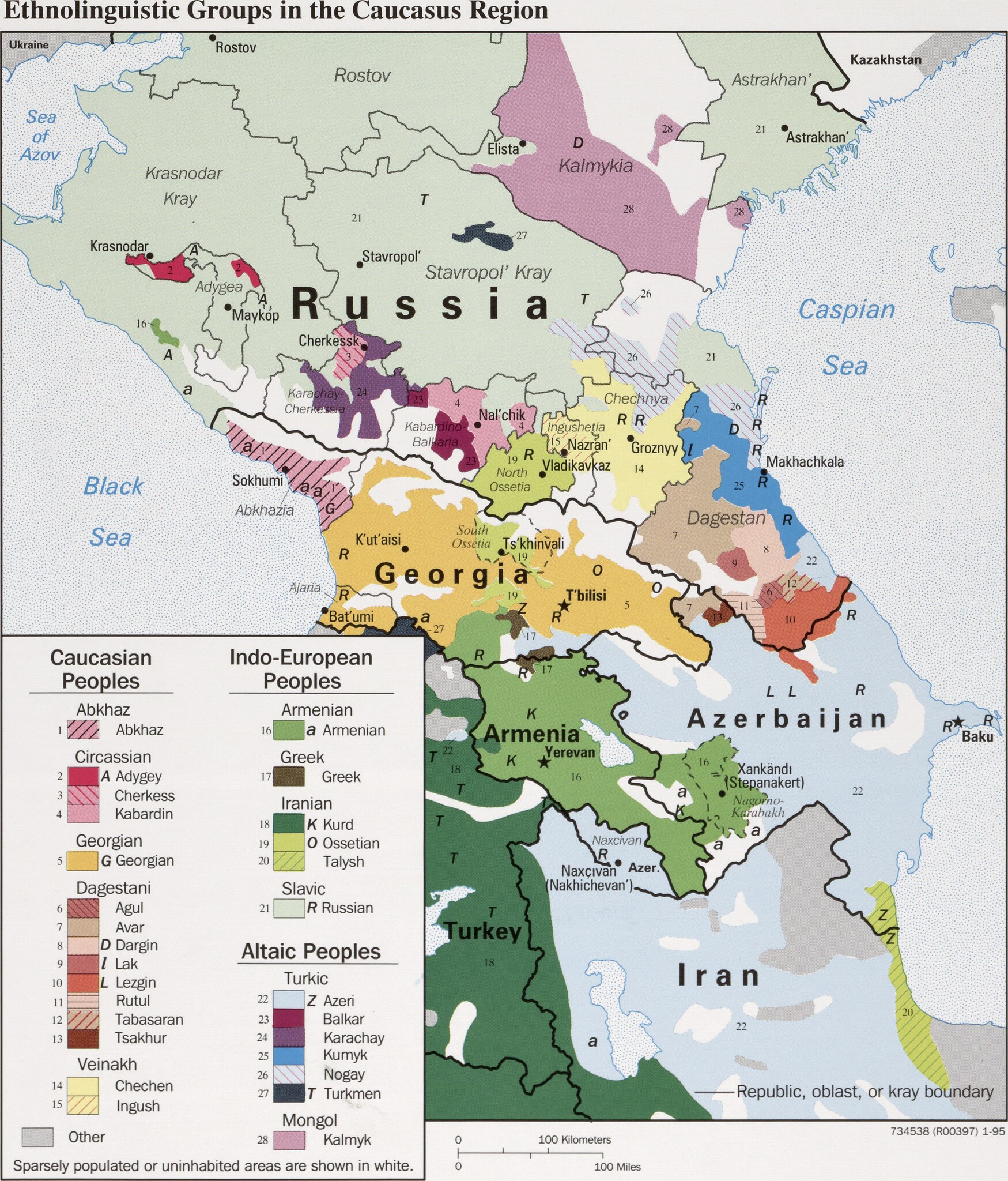
| Descrision | CIA map on the ethnolinguistic groups in the Caucasus region. National borders are thick black, regional borders within one country in thin black, and disputed borders as dotted lines. |
| Data | |
| Provenjiensa |
https://www.loc.gov/item/95680196/ (permalink: https://lccn.loc.gov/95680196)
|
| Autore | U.S. Central Intelligence Agency |
| Liçensa (Ridoparar sto file) |
Source states: "The following maps were produced by the U.S. Central Intelligence Agency, unless otherwise indicated." [1] |
| Altre version |
[]
|


Licensa de doparasion:
| Questo file multimediale è stato realizzato da un dipendente della Central Intelligence Agency durante il suo servizio. Essendo opere del governo federale statunitense, tutti i file creati dalla CIA sono in pubblico dominio.
|

|
Istoria del file
Schicia so on grupo data/or pa vedare el file come che el se presentava in tel momento indegà.
| Data/Ora | Miniadura | Dimension | Utente | Comento | |
|---|---|---|---|---|---|
| In ultima | 19:49, 29 mar 2022 | | 2 606 × 3 051 (2,46 MB) | Cherkash | TIFF from the same source (https://www.loc.gov/item/95680196/) - first maximally cropped and then converted to JPG |
| 11:12, 22 mar 2022 |  | 2 610 × 3 085 (2,41 MB) | Sette-quattro | Higher scan from the same source, from https://www.loc.gov/item/95680196/ | |
| 13:22, 4 luj 2017 |  | 984 × 1 144 (269 KB) | Mikhail Ryazanov | Reverted to version as of 13:54, 29 November 2005 (UTC) | |
| 07:22, 4 luj 2017 |  | 2 000 × 1 126 (1 024 KB) | Abdularehman | mast qalandar welfare association | |
| 07:21, 4 luj 2017 |  | 2 000 × 1 126 (1 024 KB) | Abdularehman | mast qalandar welfare association | |
| 15:54, 29 nov 2005 |  | 984 × 1 144 (269 KB) | Miaow Miaow | '''CIA map on the Ethno-Linguistic groups in the Caucasus region.''' National borders are thick black, regional borders within one country in thin black, and disputed borders as dotted lines. From http://en.wikipedia.org/wiki/Image:Caucasus-ethnic.jpg f |
Doparasion del file
Nisuna pajina ła dopara sto file
Doparasion globałe del file
St'altre wiki cua le dopara sto file: