File:Europe map 1648.PNG
Contenuti de pajine no soportà in altre łéngue.
Da Wikipedia, l'ençiclopedia libara.

File orixenałe(1 894 × 1 367 pixel, dimension del file: 195 KB, tipo MIME: image/png)

Sto file el vien da Wikimedia Commons e se połe dopararlo in altri projeti. Sto cuà vien mostrà ła descrision prexente in te ła pajina de descrision del file.

Questa immagine (categorizzazione automatica: historical map) o tutte le immagini in questa categoria o galleria dovrebbero essere ricreate usando grafica vettoriale come file SVG. Questo offre diversi vantaggi: vedi Commons:Media for cleanup per maggiori informazioni. Se è disponibile una versione in formato SVG di questa immagine, per favore caricala. Dopo aver caricato un file SVG, sostituisci questo avviso con il template {{Vector version available|nome_immagine.svg}}.

Somario

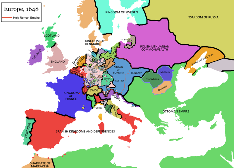
Map of Europe in 1648 (at the end of the Thirty Years War), based on free map of europe Image:BlankMap-Europe.png. Red line marks the border of the Holy Roman Empire. Information from Penguin atlas of modern history. (what year?)

Maps of the history of Europe
BCE
aC

Weichselian ice age (c. 113,000–9700) · Neolithic expansion (c. 7000–4500) · Middle Neolithic (c. 4500–4000) · Late Neolithic (c. 4000–3000) · Copper Age – Corded Ware culture (c. 2900–2350) · Copper Age – Bellbeaker culture (c. 2800–1800) · Early Bronze Age – Unetice culture (c. 2300–1600) · Late Bronze Age – Urnfield culture (c. 1300—750) · Migrations (c. 1000–100) · Hallstatt & La Tène cultures (c. 800–100) · Roman Republic (510–40) · 220 · 218 · 200 · 201–100 · 58 · 49 · 39 · 30 BCE–6 CE


CE
dC

14 · 14–37 · 60 · 60 · 69 · 80 · Migrations 100–500 · 117 · 117 · 125 · Migrations 150–774 · Economy 180 · 271 · 293–305 · 337 · 395 · c. 395 · 400 · 400 · 450 · 457–61 · 476 · 480 · Franks 481–814 · Early Slavs 500–700 · 500 · 526 · 526–600 · Christianisation to 600 · c. 550 · 650 · Pontic Steppe 650 · 665 · 800 · Vikings 800–1050 · 814 · 843–70 · 850 · 900 · 912 · 998 · 1000 · 1000 · 1054 · 1092 · First Crusade 1095–99 · 1097 · 1135 · 1142 · 1147–49 · 1190 · 1190 · 1250 · c. 1250 · 1301-1400 · 1301-1400 · 1328 · 1345 · Black Plague 1347–51 · 1360 · 1400 · Trade routes c. 1400 · 1430 · 1470 · 1490 · 1492 · 1500 · 1519 · 1550 · 1560 · Religion 1560 · Religion 1600 · Religion 1618 · 1618–48 · 1648 · 1683 · 1700 · 1701 · 1708 · 1714 · 1721 · 1725–30 · 1739–1740 · 1740 · 1748–66 · 1783–1792 · 1787 · 1787 · 1789 · 1799 · 1812 · 1812 · 1812 · 1812 · 1813 · 1815 · 1815 · 1815 · 1818 · Ottoman Empire 1830–1923 · 1848–49 · 1861 · 1867 · 1871 · 1878 · 1890 · 1905 · 1911 · 1914 · 1914 · 1919 · 1919–29 · 1923 · 1929 · 1930 · 1940 · 1941–42 · 1942–45 · Cold War 1947–91 · 1950 · 1993–2006 · 2006 to date

(this template: · view · discuss )


Licensa de doparasion:

GNU head Se autorixa ła copia, distribusion y modifegasion de sto documento soto i termani de ła liçensa de documentasion libara GNU, version 1.2 o calsiasi altra version dopo, publegada da ła Fonsasion par el Software Libaro; sensa sesion invariabiłi, testi de coertina e njianca testi de contro-coertina. Se include na copia de ła pena dita liçensa in te ła sesion intitołada Liçensa de Documentasion Libara GNU.
w:it:Creative Commons
atribussion spartisi in te ła stesa manjiera
Sto file el xe soto ła liçensa Creative Commons Atribusion-Spartisi in te ła stesa manjiera 3.0 Xenèrego.
Te si libaro:
  • de spartire in jiro – de copiar, distribuir e trasmétar sta opera
  • de modifegar – de adatar sta opera
Soto le seguenti condision:
  • atribussion – Te ghe da atribuir ƚa paternità de ƚ'opera ne i modi indicà de l'autor o da chi te gà dà l'opera en lisensa, e en modo tale da no sugerir che lori i sia d'acordo con ti o col modo che te dòpari l'opera.
  • spartisi in te ła stesa manjiera – Se te mis-ci, trasformi o dexviłupi sto laoro, te ghè da spartire łe to contribusion segondo ła stesa liçensa o na conpatibiłe a l'orixenałe.
Sto tag de copyright lo gavemo zontà ne l'ànbito de l'ajornamento de la licensa dei progeti Wikimedia.

derivative works

Opere derivate da questo file:

Didascalie

Aggiungi una brevissima spiegazione di ciò che questo file rappresenta

Elementi ritratti in questo file

raprezenta a

Istoria del file

Schicia so on grupo data/or pa vedare el file come che el se presentava in tel momento indegà.

(pì nova | pì vecia) Varda (i 10 pì novi | ) (10 | 20 | 50 | 100 | 250 | 500).
Data/OraMiniaduraDimensionUtenteComento
In ultima11:44, 14 avr 2021Miniadura de la version de le 11:44, 14 avr 20211 894 × 1 367 (195 KB)TenanReverted to version as of 16:09, 12 October 2017 (UTC) See discussion
12:47, 9 mar 2021Miniadura de la version de le 12:47, 9 mar 20211 894 × 1 367 (210 KB)TTBCamhReverted to version as of 17:18, 20 September 2018 (UTC). I don't know why Raderich is saying this is an arbitrary change—Catalonia was under the possession of the French king in 1648, following the Catalan Revolt of 1640. This map is correct and the previous one is incorrect.
14:12, 25 set 2018Miniadura de la version de le 14:12, 25 set 20181 894 × 1 367 (195 KB)RaderichReverted to version as of 21:15, 18 September 2018 (UTC) Undone arbitrary changes. Revert to correct map as uploaded by its creator Roke~commonswiki
19:18, 20 set 2018Miniadura de la version de le 19:18, 20 set 20181 894 × 1 367 (210 KB)AmbroiseLThe Catalan counties were French since they proclaimed Louis XIV of France as their king. They wanted to be French in order not to obey the king of Spain anymore. Courland was a quite free vassal state of Poland. The reverted version doesn't show it. The reverted version also doesn't show the Venetian islands in the Adriatic Sea, and the Algerian towns that France occupied. Hence, I re-revert to the more precise version.
23:15, 18 set 2018Miniadura de la version de le 23:15, 18 set 20181 894 × 1 367 (195 KB)RaderichReverted to version as of 16:09, 12 October 2017 (UTC)
12:45, 19 luj 2018Miniadura de la version de le 12:45, 19 luj 20181 894 × 1 367 (210 KB)AmbroiseLReverted to version as of 12:06, 20 January 2017 (UTC) — reverted to the version with fixed names, my mistake
12:37, 19 luj 2018Miniadura de la version de le 12:37, 19 luj 20181 894 × 1 367 (150 KB)AmbroiseLReverted to version as of 10:33, 24 September 2016 (UTC)
18:09, 12 oto 2017Miniadura de la version de le 18:09, 12 oto 20171 894 × 1 367 (195 KB)Reverted to version as of 12:42, 9 September 2016 (UTC) why is Catalonia French? Not shown as such on File:Europe_1648_westphal_1884.jpg
14:06, 20 zen 2017Miniadura de la version de le 14:06, 20 zen 20171 894 × 1 367 (210 KB)FakirbakirNames of Austria, Bohemia and Hungary are fixed.
12:33, 24 set 2016Miniadura de la version de le 12:33, 24 set 20161 894 × 1 367 (150 KB)AmbroiseLAdjunction of polish-lithuanian vassal state of Courland
(pì nova | pì vecia) Varda (i 10 pì novi | ) (10 | 20 | 50 | 100 | 250 | 500).

Ła pajina che vien ła dopara sto file:

Doparasion globałe del file

St'altre wiki cua le dopara sto file:

Varda ła doparasion globałe de sto file.

Metadati

Traesto fora da Wikipèdia - L'ençiclopedia łìbara e cołaboradiva in łéngua Vèneta "https://vec.wikipedia.org/wiki/File:Europe_map_1648.PNG"