
File:Bairisches Mundartgebiet.PNG
Dimension de sta anteprima: 800 × 505 pixel. Altre risołusion: 320 × 202 pixel | 640 × 404 pixel | 1 031 × 651 pixel.
File orixenałe (1 031 × 651 pixel, dimension del file: 43 KB, tipo MIME: image/png)

|
Questa immagine (categorizzazione automatica: linguistic map) o tutte le immagini in questa categoria o galleria dovrebbero essere ricreate usando grafica vettoriale come file SVG. Questo offre diversi vantaggi: vedi Commons:Media for cleanup per maggiori informazioni. Se è disponibile una versione in formato SVG di questa immagine, per favore caricala. Dopo aver caricato un file SVG, sostituisci questo avviso con il template {{Vector version available|nome_immagine.svg}}.
|
Somario
العربية (ar): انتشار اللهجات البافارية الحديثة:
البافارية الشمالية (البالانتية العليا).
البافارية الوسطى (البافارية الدانوبية).
البافارية الجنوبية (البافارية الألبية).
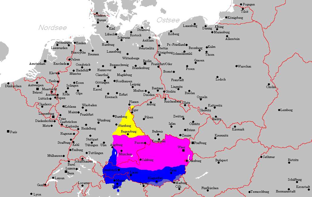
Deutsch (de): Verbreitungsgebiet der heutigen bairischen Mundarten
Nordbairisch
Mittel- oder Donaubairisch
Südbairisch
English (en): Prevalence of modern Bavarian dialects
North Bavarian
Central or Danube Bavarian
South Bavarian
русский (ru): Современные ареалы распространения баварских диалектов
жёлтый: северо-баварский
розовый: среднебаварский (австро (дунайско)-баварский)
синий: южно-баварский
español (es): Distribución del Bavariano.
Baviera del Norte
Baviera central o del Danubio
Baviera del Sur
- design by: Postmann Michael
- Quelle: Selbst erstellt.
- Hinweis: Nach den Vorgaben des "Der Fischer-Informationsatlas der Bundesrepublik Deutschland" (ISBN 3-596-24556-4 Invalid ISBN) von 1990 (S. 63) selbst erstellt. Es wurde sowohl die Karte Westmitteleuropas als auch das bayrische Sprachgebiet vom Autor händisch erstellt. Diese Karte ist gemeinfrei und darf von jedermann verwendet werden!
- Source: Self-made.
- Notes: Information derived from "The Fischer Information Atlas of the Federal Republic of Germany" (ISBN 3-596-24556-4 Invalid ISBN) from 1990 (P. 63). Both the map of west Central Europe and the Bavarian language area were by hand provided by the author. This map is in the public domain and may be used by everyone!
Licensa de doparasion:
| Sto laoro el xe stà rilassià nel Publico Dominio dal so autor, Postmann Michael. Questo el vale in tuto el mondo. In serti paesi questo podarìa no èssar legalmente possibile, in sto caso: |
Istoria del file
Schicia so on grupo data/or pa vedare el file come che el se presentava in tel momento indegà.
| Data/Ora | Miniadura | Dimension | Utente | Comento | |
|---|---|---|---|---|---|
| In ultima | 23:22, 18 feb 2012 | | 1 031 × 651 (43 KB) | Buachamer | Sechsämterland und Südvogtland hinzugefügt (siehe http://bar.wikipedia.org/wiki/Datei:Bairischer_Sprachraum2.PNG) |
| 19:56, 12 avr 2009 |  | 1 031 × 651 (57 KB) | Altaileopard | Nürnberg aus dem bayerischen Dialektraum entfernt. | |
| 06:10, 2 mar 2006 |  | 1 031 × 651 (57 KB) | Postmann Michael~commonswiki |
Doparasion del file
Ła pajina che vien ła dopara sto file:
Doparasion globałe del file
St'altre wiki cua le dopara sto file:
- Uxo de als.wikipedia.org inte le pàjine
- Uxo de ar.wikipedia.org inte le pàjine
- Uxo de ast.wikipedia.org inte le pàjine
- Uxo de be-tarask.wikipedia.org inte le pàjine
- Uxo de be.wikipedia.org inte le pàjine
- Uxo de bg.wikipedia.org inte le pàjine
- Uxo de br.wikipedia.org inte le pàjine
- Uxo de ca.wikipedia.org inte le pàjine
- Uxo de cs.wikipedia.org inte le pàjine
- Uxo de da.wikipedia.org inte le pàjine
- Uxo de de.wikipedia.org inte le pàjine
- Uxo de de.wiktionary.org inte le pàjine
- Uxo de en.wikipedia.org inte le pàjine
- Uxo de es.wikipedia.org inte le pàjine
- Uxo de et.wikipedia.org inte le pàjine
- Uxo de eu.wikipedia.org inte le pàjine
- Uxo de fa.wikipedia.org inte le pàjine
- Uxo de fr.wikipedia.org inte le pàjine
- Uxo de fy.wikipedia.org inte le pàjine
- Uxo de ga.wikipedia.org inte le pàjine
- Uxo de hak.wikipedia.org inte le pàjine
- Uxo de he.wikipedia.org inte le pàjine
- Uxo de id.wikipedia.org inte le pàjine
- Uxo de incubator.wikimedia.org inte le pàjine
- Uxo de it.wikipedia.org inte le pàjine
Varda ła doparasion globałe de sto file.