File:Ocean drainage.png
Contenuti de pajine no soportà in altre łéngue.
Da Wikipedia, l'ençiclopedia libara.

File orixenałe(1 256 × 656 pixel, dimension del file: 75 KB, tipo MIME: image/png)

Sto file el vien da Wikimedia Commons e se połe dopararlo in altri projeti. Sto cuà vien mostrà ła descrision prexente in te ła pajina de descrision del file.

Somario

Questa immagine (categorizzazione automatica: map) o tutte le immagini in questa categoria o galleria dovrebbero essere ricreate usando grafica vettoriale come file SVG. Questo offre diversi vantaggi: vedi Commons:Media for cleanup per maggiori informazioni. Se è disponibile una versione in formato SVG di questa immagine, per favore caricala. Dopo aver caricato un file SVG, sostituisci questo avviso con il template {{Vector version available|nome_immagine.svg}}.
Descrision
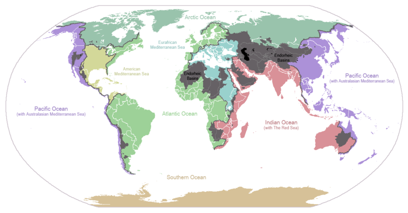
English: I made this map and hereby release it into the public domain. It shows the drainage basins for the major oceans and seas; grey areas are endorheic basins that do not drain to the ocean. Data is from the USGS Hydro1k project; information for Saskatchewan corrected by information from the Commission for Environmental Cooperation -- Citynoise
Description in large font size is used for oceans, in smaller font size is used for mediterranean seas. Only these mediterranean seas are listed which correspond to the definition of german Geographer Ernst Neef: A mediterranean sea is a sea between two Continents. Also found here: de:Mittelmeer --W like wiki (talk) 00:55, 12 March 2011 (UTC)
Français : Carte du monde des bassins versants. Les zones de couleur anthracite représentent les bassins endoréiques, qui ne sont reliés à aucun océan.
Čeština: Úmoří světových oceánů, popř. významných moří či zálivů. Legenda úmoří: fialová - Tichý oceán, růžová - Indický oceán, zelená - Atlantický oceán, azurová - Severní ledový oceán, béžová - Jižní oceán, modrá - Mexický záliv, světle modrá - Středozemní moře, šedá - oblast neústící ve světovém oceánu
Data 24 zenaro 2007 (data di caricamento originaria)
Provenjiensa Trasferito da en.wikipedia su Commons.
Autore Citynoise di Wikipedia in ingleze
Altre version File:Major endorheic basins.png

Licensa de doparasion:

Public domain Sto laoro el xe stà rilassià nel Publico Dominio dal so autor, Citynoise di Wikipedia in ingleze. Questo el vale in tuto el mondo.
In serti paesi questo podarìa no èssar legalmente possibile, in sto caso:
Citynoise el ghe dà a tuti quanti el dirito de doparar sto laoro par qualunque scopo, sensa nissuna condission, via de quele che sia richieste da la lege.

Registro original del caricamento

La pagina di descrizione originale era qui. Tutti i nomi utente che seguono sono riferiti a en.wikipedia.
  • 2007-05-20 17:59 Bolonium 1256×656×8 (50194 bytes) I made this map and hereby release it into the public domain. It shows the drainage basins for the major oceans and seas; grey areas are endorheic basins that do not drain to the ocean. -- [[User:Citynoise|Citynoise]] == Licensing == {{self
  • 2007-01-24 07:21 Citynoise 1256×656×8 (63359 bytes) I made this map and hereby release it into the public domain. It shows the drainage basins for the major oceans and seas; grey areas are endorheic basins that do not drain to the ocean.
  • 2007-01-24 06:09 Citynoise 1256×656×8 (57358 bytes) I made this map and hereby release it into the public domain. It shows the drainage basins for the major oceans and seas; grey areas are endorheic basins that do not drain to the ocean.
  • 2007-01-24 05:10 Citynoise 1256×656×8 (56360 bytes) I made this map and hereby release it into the public domain. It shows the drainage basins for the major oceans and seas; grey areas are endorheic basins that do not drain to the ocean.
  • 2007-01-24 04:55 Citynoise 1256×656×8 (56373 bytes) I made this map and hereby release it into the public domain. It shows the drainage basins for the major oceans and seas; grey areas are endorheic basins that do not drain to the ocean.

Didascalie

Aggiungi una brevissima spiegazione di ciò che questo file rappresenta
Drainage basins of the world, colored by ocean outlet. Endorheic basins not draining to an ocean are colored dark gray. Continental divides are indicated by dark lines.

Elementi ritratti in questo file

raprezenta a

Istoria del file

Schicia so on grupo data/or pa vedare el file come che el se presentava in tel momento indegà.

Data/OraMiniaduraDimensionUtenteComento
In ultima01:25, 7 oto 2015Miniadura de la version de le 01:25, 7 oto 20151 256 × 656 (75 KB)AcidSnowFixed Somalia.
02:39, 12 mar 2011Miniadura de la version de le 02:39, 12 mar 20111 256 × 656 (76 KB)W like wikiInsert Description. Big font size is used for oceans, smaller font size is used for mediterranean seas.
13:13, 30 xug 2009Miniadura de la version de le 13:13, 30 xug 20091 256 × 656 (40 KB)U7vGuntransparentize background,improve some details.
22:45, 26 luj 2008Miniadura de la version de le 22:45, 26 luj 20081 256 × 656 (62 KB)Citynoise{{Information |Description=added endorheic basins in Saskatchewan. |Source=my own work |Date=July 2008 |Author=Citynoise |Permission=all rights released |other_versions= }}
21:46, 27 nov 2007Miniadura de la version de le 21:46, 27 nov 20071 256 × 656 (49 KB)File Upload Bot (Magnus Manske) {{BotMoveToCommons|en.wikipedia}} {{Information |Description={{en|I made this map and hereby release it into the public domain. It shows the drainage basins for the major oceans and seas; grey areas are en:endorheic basins that do not drain to the

Ła pajina che vien ła dopara sto file:

Doparasion globałe del file

St'altre wiki cua le dopara sto file:

Varda ła doparasion globałe de sto file.

Metadati

Traesto fora da Wikipèdia - L'ençiclopedia łìbara e cołaboradiva in łéngua Vèneta "https://vec.wikipedia.org/wiki/File:Ocean_drainage.png"