
File:Ireland geographical map.png
No ghe xé version co rixołusion pì grande
Ireland_geographical_map.png (150 × 190 pixel, dimension del file: 50 KB, tipo MIME: image/png)
| Descrision |
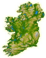
English: Topography of Ireland |
| Data | IotD Date 2005-03-18 |
| Provenjiensa |
NASA: IotD ID 16853 – http://visibleearth.nasa.gov/view_rec.php?id=17124 |
| Autore | NASA, see Image:Topography Ireland.jpg for more information |
| Liçensa (Ridoparar sto file) |
public domain |
| Altre version | original, bigger version at Image:Topography Ireland.jpg |
| Sto file multimedial el xe 'ntel publico dominio parché el xe stà creà da la NASA. La polìtega del dirito d'autor de la NASA xe che «el material de la NASA no'l xe proteto dal dirito d'autor via de quando altrimenti spesificà». (Polìtega del dirito d'autor de la NASA e polìtega de l'uso de le imagini del JPL Image Use Policy) | ||
 |
Ocio:
|
Istoria del file
Schicia so on grupo data/or pa vedare el file come che el se presentava in tel momento indegà.
| Data/Ora | Miniadura | Dimension | Utente | Comento | |
|---|---|---|---|---|---|
| In ultima | 13:39, 11 luj 2005 | | 150 × 190 (50 KB) | Kanchelskis | Map of Ireland lightened. Author:me {{GFDL}} Category: Ireland |
Doparasion del file
Łe che vien 10 pajine, łe dopara sto file:
Doparasion globałe del file
St'altre wiki cua le dopara sto file:
- Uxo de de.wikipedia.org inte le pàjine
- Uxo de en.wikipedia.org inte le pàjine
- User:Jtdirl
- User:Kwekubo
- Dingle Peninsula
- User:Zoney
- Iveragh Peninsula
- User:Ropers
- User:Gerry Lynch
- User:AndrewH
- User:Ebelular
- Inishowen
- User:Fergananim
- Mizen Head
- Sheep's Head
- Old Head of Kinsale
- User:Rye 212
- Ards Peninsula
- User:Blorg
- User:Wexfordman
- User:Meabhar~enwiki
- Howth Head
- User:Sean3000
- User:Notjim
- User:Jasonm
- User:Kgaughan
- Beara Peninsula
- User:John Carroll
- User:Bjimba
- User talk:Lochaber
- Fanad
- User:Hetch
- Islandmagee
- User:Wikipedian231
- User:Jdorney
- User:Merlante
- User:Lugnad
- Slieve League
- User:Ben-w
- Hook Peninsula
- User:Polar ice
- User:Dowlingm
- User:Frure
- User:Ventolin
- User:Dkie
- User:Colm Rice
- Mullaghmore, County Sligo
- User:Damac
- User:Ian Cheese
- User:Tpower
- User:Raemie
Varda ła doparasion globałe de sto file.