
File:Amazon-river-NASA.jpg

Dimension de sta anteprima: 600 × 600 pixel. Altre risołusion: 240 × 240 pixel | 480 × 480 pixel | 768 × 768 pixel | 1 024 × 1 024 pixel | 2 048 × 2 048 pixel | 4 096 × 4 096 pixel.
File orixenałe (4 096 × 4 096 pixel, dimension del file: 2,79 MB, tipo MIME: image/jpeg)
Somario
| Descrision |
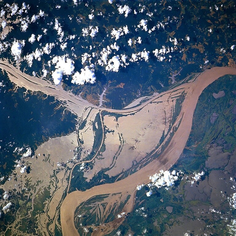
Afrikaans: STS078-751-094 Oorstroomde Amasonerivieroewers in westelike Pará-provinsie, Brasilië in Junie 1996. Die ligging is sowat halfpad tussen Manaus en die Amasonerivierdelta.
Hierdie beeld toon oorstroomde oewers van 'n klein segment van die Amasonerivier, insluitend die oerwouddorpies Oriximiná en Óbidos. Songlans op die modderige rivierwater fasiliteer die onderskeiding van land en water. Deur hierdie beeld met 'n gedetailleerde gebiedskaart te vergelyk, word dit duidelik dat die Amazonerivier sy oewers in die laagliggende dele aanliggend aan die vloedvlakte van die hoofkanaal oorstroom, en groot dele suid van die hoofkanaal staan ook onder (skoon) water. Ontbosde gebiede is binne die digbegroeide terrein aan die noordekant van die Amasonerivier waarneembaar. Die hoofkanaal van die Trombetasrivier kan suidooswaarts nagespeur word, van die linkerrand van die prent af, totdat die Trombetas tussen die oerwouddorpies Oriximiná en Óbidos met die Amasone saamvloei. English: A satellite image of a part of the Amazon River.
Esperanto: La bildo estas kopiita de wikipedia:en. La originala priskribo estas
English: Original caption: [altered to reflect rotation]
|
| Data | |
| Provenjiensa | http://earth.jsc.nasa.gov/sseop/EFS/photoinfo.pl?PHOTO=STS078-751-94 (file) |
| Autore | NASA |
| Posission del sogeto | | La posission de sta qua e de altre imagini su: OpenStreetMap |
|---|
Questa immagine o filmato è stato catalogato da uno dei centri della National Aeronautics and Space Administration (NASA) degli Stati Uniti d'Americacon il Photo ID: STS078-751-94.Questo tag non indica lo status del copyright dell'opera ad esso associato. È quindi richiesto un normale tag di copyright. Vedi Commons:Licenze per maggiori informazioni. Altre lingue:
|
Licensa de doparasion:
| Sto file multimedial el xe 'ntel publico dominio parché el xe stà creà da la NASA. La polìtega del dirito d'autor de la NASA xe che «el material de la NASA no'l xe proteto dal dirito d'autor via de quando altrimenti spesificà». (Polìtega del dirito d'autor de la NASA e polìtega de l'uso de le imagini del JPL Image Use Policy) | ||
 |
Ocio:
|
Old file history
Transferred from English-Wikipedia:
| date/time | username | edit summary |
|---|---|---|
| 02:26, 6 January 2005 | en:User:Quadell | (tagged) |
| 18:08, 18 June 2004 | en:User:Sverdrup | (Image info) |
| 18:06, 18 June 2004 | en:User:Sverdrup | (A satellite image of a part of the <a href="/wiki/Amazon_River" title="Amazon River">Amazon River</a>) |
| Annotazioni | Questa immagine è annotata: Vedi le annotazioni su Commons |
Istoria del file
Schicia so on grupo data/or pa vedare el file come che el se presentava in tel momento indegà.
| Data/Ora | Miniadura | Dimension | Utente | Comento | |
|---|---|---|---|---|---|
| In ultima | 19:13, 8 dis 2022 | | 4 096 × 4 096 (2,79 MB) | JMK | boost saturation, add some contrast |
| 19:10, 8 dis 2022 |  | 4 096 × 4 096 (2,69 MB) | JMK | rotate 180, north up | |
| 12:10, 10 nov 2022 |  | 4 096 × 4 096 (15,22 MB) | Askeuhd | Higher resolution version | |
| 16:15, 10 oto 2012 |  | 640 × 640 (418 KB) | Rotatebot | Bot: Image rotated by 180° | |
| 16:39, 29 zen 2006 |  | 640 × 640 (377 KB) | Maksim | La bildo estas kopiita de wikipedia:en. La originala priskribo estas: A satellite image of a part of the Amazon River. {{PD-USGov-NASA}} '''Original caption:''' :''STS078-751-094 Amazon River, Western Para Province, Brazil June 1996'' :''This image s |
Doparasion del file
Ła pajina che vien ła dopara sto file:
Doparasion globałe del file
St'altre wiki cua le dopara sto file:
- Uxo de ar.wikipedia.org inte le pàjine
- Uxo de ast.wikipedia.org inte le pàjine
- Uxo de azb.wikipedia.org inte le pàjine
- Uxo de ca.wikipedia.org inte le pàjine
- Uxo de ce.wikipedia.org inte le pàjine
- Uxo de cv.wikipedia.org inte le pàjine
- Uxo de en.wikipedia.org inte le pàjine
- Uxo de eo.wikipedia.org inte le pàjine
- Uxo de es.wikipedia.org inte le pàjine
- Uxo de eu.wikipedia.org inte le pàjine
- Uxo de fa.wikipedia.org inte le pàjine
- Uxo de fr.wikipedia.org inte le pàjine
- Uxo de fy.wikipedia.org inte le pàjine
- Uxo de id.wikipedia.org inte le pàjine
- Uxo de ilo.wikipedia.org inte le pàjine
- Uxo de kk.wikipedia.org inte le pàjine
- Uxo de krc.wikipedia.org inte le pàjine
- Uxo de ml.wikipedia.org inte le pàjine
- Uxo de mr.wikipedia.org inte le pàjine
- Uxo de nl.wikipedia.org inte le pàjine
- Uxo de no.wikipedia.org inte le pàjine
- Uxo de os.wikipedia.org inte le pàjine
- Uxo de pl.wiktionary.org inte le pàjine
- Uxo de pt.wikipedia.org inte le pàjine
- Uxo de rm.wikipedia.org inte le pàjine
- Uxo de ru.wikipedia.org inte le pàjine
- Uxo de uk.wikipedia.org inte le pàjine
- Uxo de vi.wikipedia.org inte le pàjine
- Uxo de www.wikidata.org inte le pàjine
- Uxo de zh-yue.wikipedia.org inte le pàjine
- Uxo de zh.wikipedia.org inte le pàjine