
File:Satellite image of Bolivia in June 2002.jpg

Dimension de sta anteprima: 521 × 600 pixel. Altre risołusion: 208 × 240 pixel | 417 × 480 pixel | 667 × 768 pixel | 889 × 1 024 pixel | 1 778 × 2 048 pixel | 5 279 × 6 079 pixel.
File orixenałe (5 279 × 6 079 pixel, dimension del file: 4,02 MB, tipo MIME: image/jpeg)
Somario
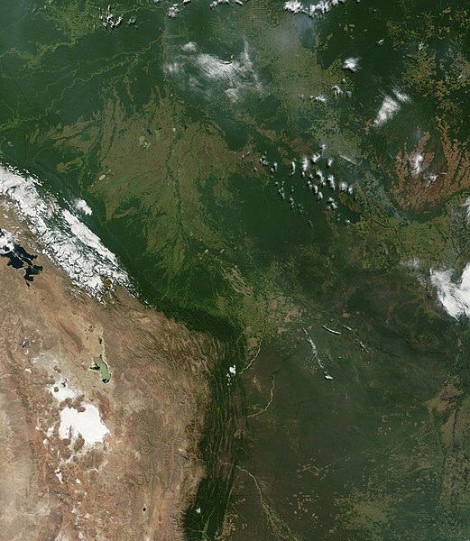
| Descrision | Satellite image of Bolivia in June 2002. Normally obscured by clouds, Bolivia is amazingly clear in this true-color MODIS image acquired June 20, 2002. Bounded by Brazil to the north and east, Paraguay and Argentina to the south, and Peru and Chile to the west, Bolivia is completely landlocked. A good portion of Bolivia is dominated by the Andes, but it also lays claim to lush forests and pasture lands in the Amazon Basin.Bolivia's agricultural crops include soybeans, coffee, coca, cotton, corn, sugarcane, rice, potatoes, and timber. A number of agricultural plots are visible in central Bolivia. Some large plots are arranged in a circular star shape, with water sources at the center and the agricultural plots radiating outwards. Adjacent to them (down and to the right) are more traditional shaped plots (more rectangular).One of Bolivia's main exports is tropical timber. Visible in this image are areas where the timber has been harvested. The deforestation patterns tend to follow major roads first, then smaller roads adjoining main roads. These patterns resemble the growth of ice crystals and are best viewed in the higher resolutions of this image. Deforestation is visible along the green edge of the Andes in central Bolivia. |
| Data | |
| Provenjiensa | Slightly cropped from: http://visibleearth.nasa.gov/view_rec.php?id=3261 |
| Autore | Jacques Descloitres, MODIS Land Rapid Response Team, NASA/GSFC |
Licensa de doparasion:
| Sto file multimedial el xe 'ntel publico dominio parché el xe stà creà da la NASA. La polìtega del dirito d'autor de la NASA xe che «el material de la NASA no'l xe proteto dal dirito d'autor via de quando altrimenti spesificà». (Polìtega del dirito d'autor de la NASA e polìtega de l'uso de le imagini del JPL Image Use Policy) | ||
 |
Ocio:
|
Istoria del file
Schicia so on grupo data/or pa vedare el file come che el se presentava in tel momento indegà.
| Data/Ora | Miniadura | Dimension | Utente | Comento | |
|---|---|---|---|---|---|
| In ultima | 18:40, 18 dis 2004 | | 5 279 × 6 079 (4,02 MB) | Hautala | {{PD-USGov-NASA}} Satellite image of Bolivia in June 2002. Slightly cropped image taken originally from http://visibleearth.nasa.gov/cgi-bin/viewrecord?16839 . Normally obscured by clouds, Bolivia is amazingly clear in this true-color MODIS image acquired |
Doparasion del file
Nisuna pajina ła dopara sto file
Doparasion globałe del file
St'altre wiki cua le dopara sto file:
- Uxo de af.wikipedia.org inte le pàjine
- Uxo de ast.wikipedia.org inte le pàjine
- Uxo de de.wikipedia.org inte le pàjine
- Uxo de dz.wikipedia.org inte le pàjine
- Uxo de en.wikipedia.org inte le pàjine
- Uxo de es.wikipedia.org inte le pàjine
- Uxo de fr.wikipedia.org inte le pàjine
- Uxo de gcr.wikipedia.org inte le pàjine
- Uxo de hi.wikipedia.org inte le pàjine
- Uxo de hr.wikipedia.org inte le pàjine
- Uxo de ne.wikipedia.org inte le pàjine
- Uxo de qu.wikipedia.org inte le pàjine
- Uxo de sr.wikipedia.org inte le pàjine
- Uxo de te.wikipedia.org inte le pàjine
- Uxo de uk.wikipedia.org inte le pàjine