
File:Bih IEBLinRed.png
Bih_IEBLinRed.png (329 × 352 pixel, dimension del file: 23 KB, tipo MIME: image/png)
Somario

|
Questa immagine (categorizzazione automatica: historical map) o tutte le immagini in questa categoria o galleria dovrebbero essere ricreate usando grafica vettoriale come file SVG. Questo offre diversi vantaggi: vedi Commons:Media for cleanup per maggiori informazioni. Se è disponibile una versione in formato SVG di questa immagine, per favore caricala. Dopo aver caricato un file SVG, sostituisci questo avviso con il template {{Vector version available|nome_immagine.svg}}.
|
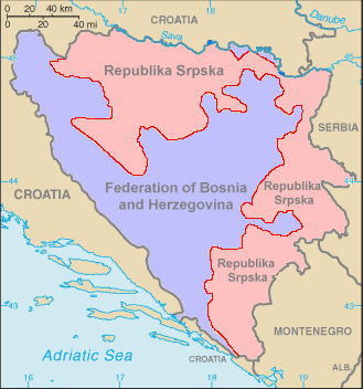
This is a map of Bosnia-Herzegovina (from the World Factbook copia archiviata at the Wayback Machine) with the Inter-Entity Boundary Line (IEBL) in red. The map has been made simpler by removing the names of the cities, leaving only the two entities. Color has added for the entities as well. The labels have also been redone, since they did not show up well against the colors. This map is based off the one in the World Factbook as mirrored by the PCL.
Licensa de doparasion:
Ovo je ispravna karta .Zaboravili ste Brcko district je posebna jedinica koje ne pripada nikome a nije oznaceno[1]
![[1]](http://3.bp.blogspot.com/-I8wsRh6MpT4/UPRnAon0eYI/AAAAAAAAAFI/7NnMbKQExvg/s1600/Federalna+struktura+BiH.jpg)
Quest'immagine è in pubblico dominio perché contiene materiale proveniente dal World Factbook pubblicato dalla Central Intelligence Agency degli Stati Uniti d'America.
|
 |
Istoria del file
Schicia so on grupo data/or pa vedare el file come che el se presentava in tel momento indegà.
| Data/Ora | Miniadura | Dimension | Utente | Comento | |
|---|---|---|---|---|---|
| In ultima | 07:17, 29 oto 2006 | | 329 × 352 (23 KB) | Hoshie | This is a map of Bosnia-Herzegovina (from the [https://www.cia.gov/cia/publications/factbook/maps/bk-map.gif World Factbook]) with the Inter-Entity Boundary Line (IEBL) in red. The map has been made simpler by removing the |
Doparasion del file
Ła pajina che vien ła dopara sto file:
Doparasion globałe del file
St'altre wiki cua le dopara sto file:
- Uxo de de.wikipedia.org inte le pàjine
- Uxo de sr.wikipedia.org inte le pàjine